NASADEM (SRTM reprocessed)#
nasadem · theme terrain · no data
NASA’s 2020 reprocessing of the February 2000 SRTM C-band radar mission: 30 m, 60°N to 56°S, voids filled with ASTER GDEM and other sources, referenced to the EGM96 geoid. The same surface as SRTM GL1 with better geolocation and fewer voids, and the credential-free way to get an SRTM-heritage DEM.
import easysnowdata as esd

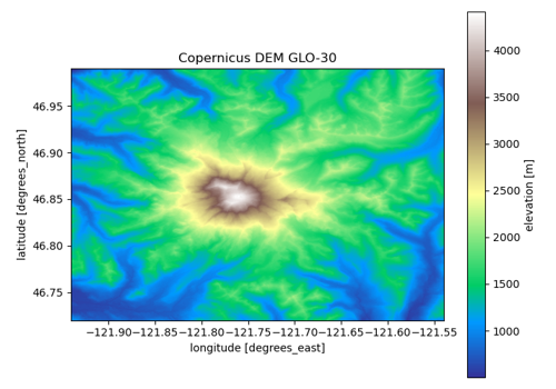
aoi = (-121.94, 46.72, -121.54, 46.99)   # Mount Rainier
data = esd.terrain.dem.load(aoi)
No account needed for the default route
source="planetary-computer" is open. source="gee" needs earthengine — see the credentials page.
Sources#
2 routes serve this product; the first is the default and source= picks another. The return contract is the same either way.
source |
provider |
credentials |
resolution |
extent |
temporal |
latency |
notes |
|---|---|---|---|---|---|---|---|
|
stac |
none |
30 m |
60°N to 56°S |
static (acquired February 2000; released 2020) |
— |
signed hrefs, anonymous; one COG per 1° tile |
|
gee |
earthengine |
30 m |
60°N to 56°S |
static (acquired February 2000; released 2020) |
— |
the same product as one global image |
Where each route points#
planetary-computer— Planetary Computer no datanasademgee— Earth Engine no dataNASA/NASADEM_HGT/001
Variables#
variable |
units |
dtype |
nodata |
categorical |
|---|---|---|---|---|
|
m |
float32 |
-32768 |
no |
Provenance#
Licence · Public domain (NASA data)
DOI · 10.5067/MEaSUREs/NASADEM/NASADEM_HGT.001
Cite the data as
NASA JPL (2020). NASADEM Merged DEM Global 1 arc second V001. NASA EOSDIS Land Processes DAAC. https://doi.org/10.5067/MEaSUREs/NASADEM/NASADEM_HGT.001
Documentation
Loader · easysnowdata.terrain.dem.load
Gallery examples#