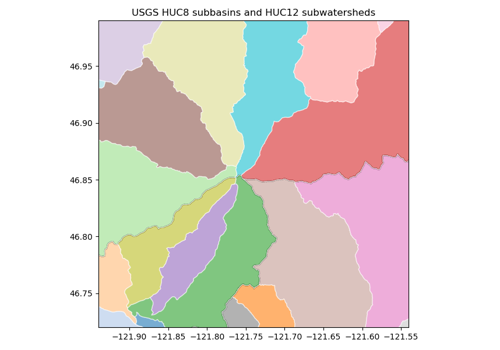
USGS Watershed Boundary Dataset (HUC)#
huc · theme hydro · live
Hydrologic unit boundaries (HUC2 to HUC16) for the United States, from the USGS/NRCS Watershed Boundary Dataset.
import easysnowdata as esd

aoi = (-121.94, 46.72, -121.54, 46.99)   # Mount Rainier
data = esd.hydro.basins.huc(aoi, level=8)
No account needed for the default route
source="usgs-wbd" is open. source="gee" needs earthengine — see the credentials page.
Sources#
2 routes serve this product; the first is the default and source= picks another. The return contract is the same either way.
source |
provider |
credentials |
resolution |
extent |
temporal |
latency |
notes |
|---|---|---|---|---|---|---|---|
|
vector_http |
none |
— |
United States |
continuously updated |
— |
the public ArcGIS REST service: no credentials, server-side spatial query, paged because it times out on large pages |
|
gee |
earthengine |
— |
United States |
static (2017) |
— |
the 2017 snapshot; the REST service is newer and needs no account |
Where each route points#
usgs-wbd— USGS WBD (ArcGIS REST) livehttps://hydro.nationalmap.gov/arcgis/rest/services/wbd/MapServergee— Earth Engine liveUSGS/WBD/2017/HUC{level}
Variables#
variable |
units |
dtype |
nodata |
categorical |
|---|---|---|---|---|
|
— |
— |
— |
no |
|
— |
— |
— |
no |
|
km2 |
— |
— |
no |
Provenance#
Licence · Public domain (US government data)
DOI · 10.3133/tm11A3
Cite the data as
Jones, K.A., Niknami, L.S., Buto, S.G., and Decker, D. (2022). Federal standards and procedures for the national Watershed Boundary Dataset (WBD), 5th ed. U.S. Geological Survey Techniques and Methods 11-A3.
Documentation
Loader · easysnowdata.hydro.basins.huc
Gallery examples#