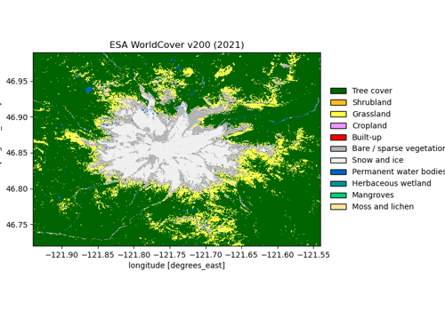
ESA WorldCover land cover#
esa-worldcover · theme land · live
Global 10 m land cover for 2020 (v100) and 2021 (v200), 11 classes from the FAO Land Cover Classification System. The project ended at v200; Copernicus LCFM on CDSE is the successor.
import easysnowdata as esd

aoi = (-121.94, 46.72, -121.54, 46.99)   # Mount Rainier
data = esd.land.landcover.load(aoi)
No account needed
Every route to this product is open. Nothing to set up.
Sources#
2 routes serve this product; the first is the default and source= picks another. The return contract is the same either way.
source |
provider |
credentials |
resolution |
extent |
temporal |
latency |
notes |
|---|---|---|---|---|---|---|---|
|
stac |
none |
10 m |
global |
2020, 2021 |
— |
signed hrefs, anonymous; both versions in one collection |
|
raster_http |
none |
10 m |
global |
2020, 2021 |
— |
public eu-central-1 bucket, no signing and no STAC; the tile grid (esa_worldcover_grid.geojson) is cached on first use |
Where each route points#
planetary-computer— Planetary Computer liveesa-worldcoveraws-open-data— AWS Open Data bucket livehttps://esa-worldcover.s3.eu-central-1.amazonaws.com/<version>/<year>/map
Variables#
variable |
units |
dtype |
nodata |
categorical |
|---|---|---|---|---|
|
— |
uint8 |
0 |
yes (11 classes) |
landcover classes (11)
value |
meaning |
|---|---|
10 |
Tree cover |
20 |
Shrubland |
30 |
Grassland |
40 |
Cropland |
50 |
Built-up |
60 |
Bare / sparse vegetation |
70 |
Snow and ice |
80 |
Permanent water bodies |
90 |
Herbaceous wetland |
95 |
Mangroves |
100 |
Moss and lichen |
Provenance#
Licence · CC BY 4.0
DOI · 10.5281/zenodo.7254221
Cite the data as
Zanaga, D., et al. (2022). ESA WorldCover 10 m 2021 v200. Zenodo.
Documentation
Loader · easysnowdata.land.landcover.load
Gallery examples#