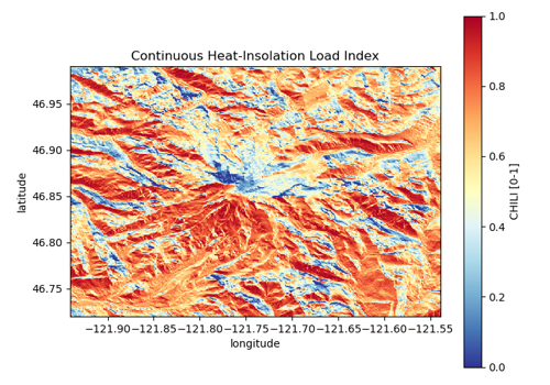
CHILI (Continuous Heat-Insolation Load Index)#
chili · theme terrain · live
Topographic heat-load index from ALOS AW3D30 (Theobald et al. 2015), 90 m, 70°N-70°S. Native values are the 0-1 index scaled to 0-255; warm slopes are above 0.767 and cool slopes below 0.448.
import easysnowdata as esd

aoi = (-121.94, 46.72, -121.54, 46.99)   # Mount Rainier
data = esd.terrain.chili.load(aoi)
Credentials
The default route needs earthengine; see the credentials page for the setup.
Sources#
source |
provider |
credentials |
resolution |
extent |
temporal |
latency |
notes |
|---|---|---|---|---|---|---|---|
|
gee |
earthengine |
90 m |
70°N-70°S |
static |
— |
native values by default (the AOI-relative rescaling of topography.get_chili is opt-in); a DEM-computed heat-load index is the planned credential-free route |
Where each route points#
gee— Earth Engine liveCSP/ERGo/1_0/Global/ALOS_CHILI
Variables#
variable |
units |
dtype |
nodata |
categorical |
|---|---|---|---|---|
|
1 |
float32 |
— |
no |
Provenance#
Licence · CC BY 4.0
DOI · 10.1371/journal.pone.0143619
Cite the data as
Theobald, D. M., Harrison-Atlas, D., Monahan, W. B., Albano, C. M. (2015). Ecologically-Relevant Maps of Landforms and Physiographic Diversity for Climate Adaptation Planning. PLoS ONE 10(12): e0143619.
Documentation
Loader · easysnowdata.terrain.chili.load
Gallery examples#