GEDTM30 global ensemble digital terrain model (30 m)#
gedtm30 · theme terrain · no data
OpenGeoHub’s global 30 m bare-earth terrain model (Ho & Hengl 2025): Copernicus, ALOS World 3D and other DEMs fused with object-height models by a two-stage random forest fitted to about 30 billion ICESat-2 and GEDI ground returns, so forest canopy and buildings are removed. 62°S to 84°N, EGM2008 geoid. The global counterpart of 3DEP: the DEM to use for slope, aspect or snow depth under forest outside the United States. Machine-learned, so verify it before relying on it where it matters.
import easysnowdata as esd

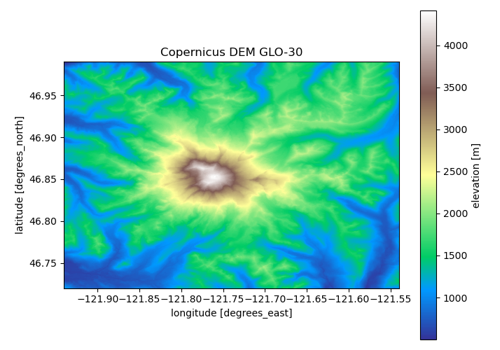
aoi = (-121.94, 46.72, -121.54, 46.99)   # Mount Rainier
dem_da = esd.terrain.dem.load(aoi)
No account needed
Every route to this product is open. Nothing to set up.
Sources#
source |
provider |
credentials |
resolution |
extent |
temporal |
latency |
notes |
|---|---|---|---|---|---|---|---|
|
opentopography |
none |
30 m |
62°S to 84°N |
static (inputs acquired 2006-2015; released 2025) |
— |
OpenTopography’s static STAC catalog: anonymous COGs on SDSC storage, no search API, tiles picked by their bbox; one global COG (v1.2), float32 |
Where each route points#
opentopography— OpenTopography no datahttps://portal.opentopography.org/stac/items/GEDTM30_be.json
Variables#
variable |
units |
dtype |
nodata |
categorical |
|---|---|---|---|---|
|
m |
float32 |
3.4028234663852886e+38 |
no |
Provenance#
Licence · CC BY 4.0
DOI · 10.5069/G9BV7DT1
Cite the data as
Ho, Y.-F., & Hengl, T. (2025). Global ensemble digital terrain model 30m (GEDTM30) (Version v20250619) [Data set]. Distributed by OpenTopography. https://doi.org/10.5069/G9BV7DT1
Documentation
Loader · easysnowdata.terrain.dem.load
Gallery examples#